The Yangtze River "digital twin" is revolutionizing flood management and mitigation

 The Yangtze River "digital twin" is revolutionizing flood management and mitigation along Asia's longest river. This innovative technology creates a virtual replica of the entire Yangtze River and the Three Gorges Dam, allowing for real-time monitoring, simulation, and prediction of flood events.
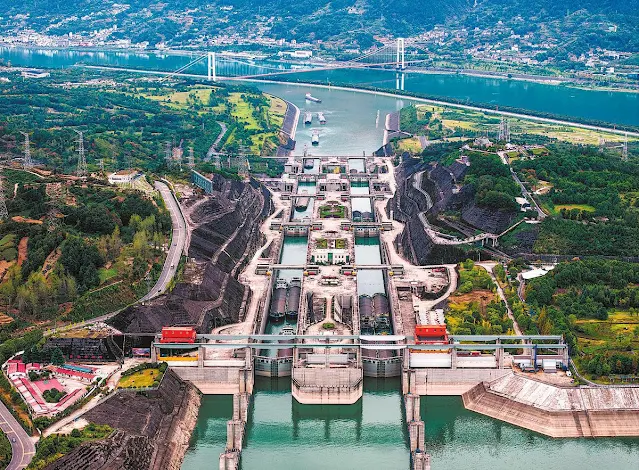
 

Ships pass the five-tier ship lock of the Three Gorges Project in October. WANG GANG/XINHUA

Key Features and Benefits

Real-time Monitoring: The digital twin provides instant access to critical metrics of the Three Gorges Dam, enabling continuous monitoring of dam pressure and safety.

Flood Prediction: By analyzing existing flood data in the upper reaches, the system can predict future flood trends in the middle and lower reaches of the Yangtze.


Early Warning System: The digital twin enables earlier and more accurate flood warnings, allowing for safer evacuations and more targeted flood defense measures.

Comprehensive Database: A database of 706 polders along the Yangtze has been established, along with information on the river's mainstream and dynamic flow.

3D Visualization: The system offers a three-dimensional view of flood inundation in real-time, providing a "God's-eye view" of the entire river basin.


Practical Applications

The digital twin has already demonstrated its effectiveness in several real-world scenarios:

Widespread Flood Warning: On July 2, 2024, the system predicted that approximately 2,430 kilometers of dikes would exceed water warning levels across five provinces.

Targeted Evacuations: In the Guiliangzhou area of Hubei province, early warnings on June 30 led to timely evacuations and proactive flood diversion measures, significantly reducing potential damage.

Rapid Response to Breaches: When a sudden breach occurred in the Tuanzhou area of Dongting Lake, the digital twin quickly generated a flood inundation risk map, enabling dynamic analysis of the impact and informing response strategies.

Dike Health Monitoring: The system facilitates regular "health checks" of the dikes, using radar technology to detect gaps and leakages. This proactive approach allows for timely reinforcement and maintenance.


Broader Impact

The Yangtze digital twin is part of a larger trend in water management. China has launched a Digital-Twin River Basin campaign, aiming to fully digitalize its major river basins by 2025. This approach is transforming water governance, enabling more precise, data-driven decision-making and improving resilience to climate change impacts.

By providing comprehensive, real-time data and predictive capabilities, the Yangtze digital twin is significantly enhancing flood management, reducing casualties and property losses, and contributing to more sustainable water resource management along one of the world's most important river systems.

Comments

Popular posts from this blog

Von Kármán vortex cloud swirls from Jeju Island of Republic of Korea (South Korea)

    This Copernicus Sentinel-3 image acquired on 19 April 2021 shows several vortical cloud patterns swirling downwind south of the Spanish Canary Islands, off the coast of northwestern Africa.   These beautiful spiral clouds, known as Von Kármán vortices, form when atmospheric circulation is disturbed by the presence of mountainous obstacles. The peculiar spiral clouds which can be seen in this image were formed as the wind airflow was deflected by the relief of the Canary Islands. These Von Kármán vortices can be seen extending 400 km southwest due to the strong trade winds that were blowing at the time the image was acquired.   The study of atmospheric phenomena is fundamental to the understanding the fluid dynamics that underly numerous scenarios of our daily lives, from aircraft take-offs to the change in weather conditions. Open data supplied by the Copernicus Sentinel-3 mission are crucial in the advancement of scientific knowledge on cloud dynamic...

Major Storm Hits Northern California: Flash Flooding and Rockslides Threaten Region

  Major Storm Hits Northern California: Flash Flooding and Rockslides Threaten Region   SANTA ROSA, Calif. (AP) — A powerful storm swept through Northern California on Wednesday night, bringing heavy rain and snow, and posing significant threats of flash flooding and rockslides.   Key Details - Rainfall: Up to 16 inches (41 cm) of rain forecasted in Northern California and southwestern Oregon through Friday. - Snowfall: Over a foot of snow already dumped in the Cascades, with more expected in the northern Sierra Nevada. - Wind: Wind gusts could reach up to 75 mph (121 kph) in mountain areas. - Power Outages: Nearly 376,000 reports in Washington state due to strong winds and rain. - Casualties: Two fatalities in Washington state due to falling trees.   CNN news Impact on Northern California - Santa Rosa: Experienced about 5 inches (13 cm) of rain within 24 hours. - Road Closures: Southbound Interstate 5 closed for 11 miles (18 km) due to extreme weather co...

Climate change is changing hurricanes. How?

Climate change is changing hurricanes. How?  #EarthScience #NASA #Hurricanes #ClimateChange  Image Descriptions 1: An image of Hurricane Idalia from space taken by an astronaut aboard the ISS is positioned in the bottom half of the image. White text reads “Climate change is affecting Hurricanes.” with “hurricanes” in blue lettering on a black background at the top.  2: An image divided into four panels by blue lines. The left most panel runs top to bottom showing a piece of the image from the previous slide while the other three panels divide the right side of the image. The top is white text on a black background and reads “How do hurricanes form?”. The middle shows an image of an eye of a hurricane from space. The bottom panel reads “4 main ingredients:” in blue text and lists “Warm ocean waters near the surface, High humidity in the air, Favorable winds, and A pre-existing disturbance (like a cluster of thunderstorms”  3: An image with white text on a black backgr...