Is climate change accelerating and is it worse than we expected? July 2023 was the hottest month on record

 Is climate change accelerating and is it worse than we expected?

 16 August 2023, By Michael Le Page


With temperature records tumbling, it is only natural to worry about cascading tipping points, but the reality is far more nuanced


Unprecedented bouts of extreme weather and related events around the world raise the question of whether climate scientists have underestimated how fast the world is warming and how severe the consequences will be. Here are the key facts you need to know.


Is the world warming faster than we expected?

What made July 2023 the hottest month ever recorded?

Extreme weather and temperatures made July 2023 a shocking month, with human-driven global warming, the El Niño climate pattern and perhaps even a 2022 volcanic eruption contributing to the broken records
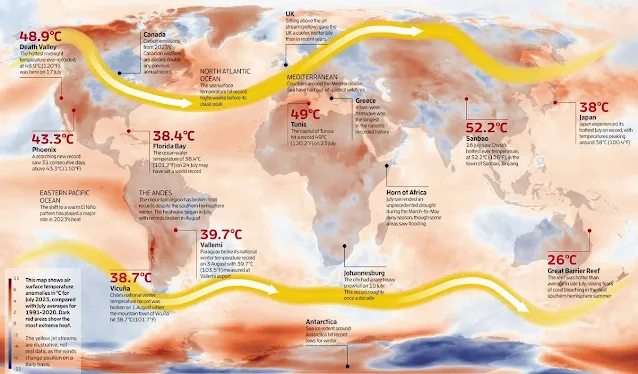
 

Data source: ERA5. Credit: Copernicus Climate Change Service/ECMWF

July 2023 was the hottest month on record, the European Centre for Medium-Range Weather Forecasts confirmed on 8 August. More broadly, this year’s overall global average temperature is shaping up to be the hottest ever measured.


The main reason for these extremes is the long-term effect of humans releasing ever more greenhouse gases into the atmosphere, plus the shift to a warm El Niño pattern in the Pacific Ocean, says Michael McPhaden at the US National Oceanic and Atmospheric Administration.


He says El Niño’s effect is especially striking after several cooler years in the Pacific “masked” a steady rise in the atmospheric concentration of carbon dioxide an increase of about 4 per cent since the last big El Niño in 2016.


The heat was also boosted by a wavy jet stream pattern (in yellow, above) that formed simultaneous “heat domes” of trapped hot air in North America, Europe and China. Whether climate change makes such heat domes themselves more likely is an active area of research.

Comments

Popular posts from this blog

Von Kármán vortex cloud swirls from Jeju Island of Republic of Korea (South Korea)

    This Copernicus Sentinel-3 image acquired on 19 April 2021 shows several vortical cloud patterns swirling downwind south of the Spanish Canary Islands, off the coast of northwestern Africa.   These beautiful spiral clouds, known as Von Kármán vortices, form when atmospheric circulation is disturbed by the presence of mountainous obstacles. The peculiar spiral clouds which can be seen in this image were formed as the wind airflow was deflected by the relief of the Canary Islands. These Von Kármán vortices can be seen extending 400 km southwest due to the strong trade winds that were blowing at the time the image was acquired.   The study of atmospheric phenomena is fundamental to the understanding the fluid dynamics that underly numerous scenarios of our daily lives, from aircraft take-offs to the change in weather conditions. Open data supplied by the Copernicus Sentinel-3 mission are crucial in the advancement of scientific knowledge on cloud dynamic...

Major Storm Hits Northern California: Flash Flooding and Rockslides Threaten Region

  Major Storm Hits Northern California: Flash Flooding and Rockslides Threaten Region   SANTA ROSA, Calif. (AP) — A powerful storm swept through Northern California on Wednesday night, bringing heavy rain and snow, and posing significant threats of flash flooding and rockslides.   Key Details - Rainfall: Up to 16 inches (41 cm) of rain forecasted in Northern California and southwestern Oregon through Friday. - Snowfall: Over a foot of snow already dumped in the Cascades, with more expected in the northern Sierra Nevada. - Wind: Wind gusts could reach up to 75 mph (121 kph) in mountain areas. - Power Outages: Nearly 376,000 reports in Washington state due to strong winds and rain. - Casualties: Two fatalities in Washington state due to falling trees.   CNN news Impact on Northern California - Santa Rosa: Experienced about 5 inches (13 cm) of rain within 24 hours. - Road Closures: Southbound Interstate 5 closed for 11 miles (18 km) due to extreme weather co...

Climate change is changing hurricanes. How?

Climate change is changing hurricanes. How?  #EarthScience #NASA #Hurricanes #ClimateChange  Image Descriptions 1: An image of Hurricane Idalia from space taken by an astronaut aboard the ISS is positioned in the bottom half of the image. White text reads “Climate change is affecting Hurricanes.” with “hurricanes” in blue lettering on a black background at the top.  2: An image divided into four panels by blue lines. The left most panel runs top to bottom showing a piece of the image from the previous slide while the other three panels divide the right side of the image. The top is white text on a black background and reads “How do hurricanes form?”. The middle shows an image of an eye of a hurricane from space. The bottom panel reads “4 main ingredients:” in blue text and lists “Warm ocean waters near the surface, High humidity in the air, Favorable winds, and A pre-existing disturbance (like a cluster of thunderstorms”  3: An image with white text on a black backgr...