Oil from the Amazon? Proposal to drill at river’s mouth worries researchers
Oil from the Amazon? Proposal to drill at river’s mouth worries researchers
Energy firm Petrobras says any leaked oil would not reach the Brazilian coast, but scientists are concerned about a vast reef nearby.
 |
| Water flows with great force from the Amazon River into the sea at its mouth. Credit: Universal Images Group North America LLC/Alamy |
A Brazilian petrochemical company wants to drill exploratory oil wells in the ocean near the mouth of the Amazon, one of the world’s biggest rivers. Although Brazil’s environmental-protection agency has so far rejected the state-run firm’s request, researchers worry that the plan might one day be approved, encouraging further offshore drilling in the area. In particular, they are concerned about the effects of the drilling — and inevitable oil leaks — on a vast reef system nearby.
“There’s a palpable risk of an oil spill if activities proceed — the fact it is an exploratory well for studying the region’s potential for deep-sea oil doesn’t exempt it from accidents,” says Carlos Rezende, a marine biologist at the State University of Northern Rio de Janeiro in Campos dos Goytacazes, Brazil.
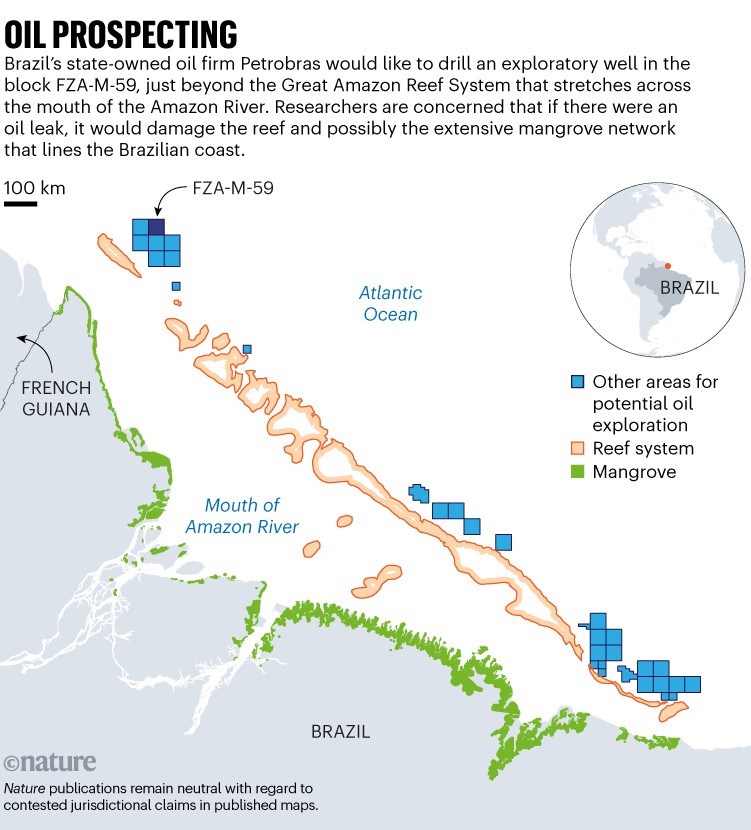
In May, the Brazilian Institute for the Environment and Renewable Natural Resources (Ibama) turned down oil firm Petrobras’s application to drill in what’s known as the FZA-M-59 block, a parcel of sea floor about 175 kilometres from the coast of northern Brazil, near the border with French Guiana, and about 540 kilometres from the mouth of the Amazon River (see ‘Oil prospecting’). The agency said that the company’s assessment of environmental impacts and its emergency plan in the event of a leak are insufficient. Petrobras, which is based in Rio de Janeiro, has since appealed and filed a new request.
The company defended itself to Nature, saying that in the planned drilling location, “there is no record of any nearby conservation units, nor is it located near rivers, lakes, floodplains or reef systems”. But Rezende argues that the Great Amazon Reef System is only about 50 kilometres from the site, and that oil in the water could travel that distance.

Source: Adapted from L. S. Araujo et al. Mar. Pol. 128, 104465 (2021)
Threats to the reef system, which lies 70–220 metres below the ocean surface, are of great concern to some scientists. It has been difficult to explore the area because of turbulent waters, but studies estimate that the reef spans between 9,500 and 56,000 square kilometres across the mouth of the Amazon1,2. When it was first described by scientists in the 1970s, researchers did not observe rich biodiversity. But studies in 20162 and 20193 found a thriving ecosystem that’s home to corals, sponges and fish communities.
“It is huge, and it is sensitive,” says Ronaldo Francini-Filho, a marine ecosystems researcher at the University of São Paulo in Brazil. “And we don’t know even 5% of what’s down there.”
Rodrigo de Moura, a marine ecologist at the Federal University of Rio De Janeiro who has mapped reefs off the Amazon’s mouth, agrees. “There are a lot of known unknowns there,” he says. Because researchers don’t know a lot about the reef’s habitats and water circulation, “a comprehensive evaluation of the risks from oil and gas exploitation is currently impossible”, he adds.
A promising block
If the project is approved, it could set a precedent to allow drilling at 15 other deep-sea sites nearby that are flagged for exploration, says Suely Araújo, a senior policy specialist at the Climate Observatory, a Rio de Janeiro-based civil-society coalition focused on climate-change policy.
So far, 95 exploratory wells have been drilled in the region without striking much oil; some natural-gas deposits have been found, but none big enough for commercial purposes. These wells were all in shallow waters, but FZA-M-59 is at a depth of 2,800 metres, in a part of the ocean that some researchers think is more promising. Egberto Pereira, an organic geochemist at Rio de Janeiro State University, says it’s possible that oil lies beneath FZA-M-59, because the area’s landscape and rock composition are similar to those of an oil-rich region off Guyana, where oil company ExxonMobil has operated since 2015.

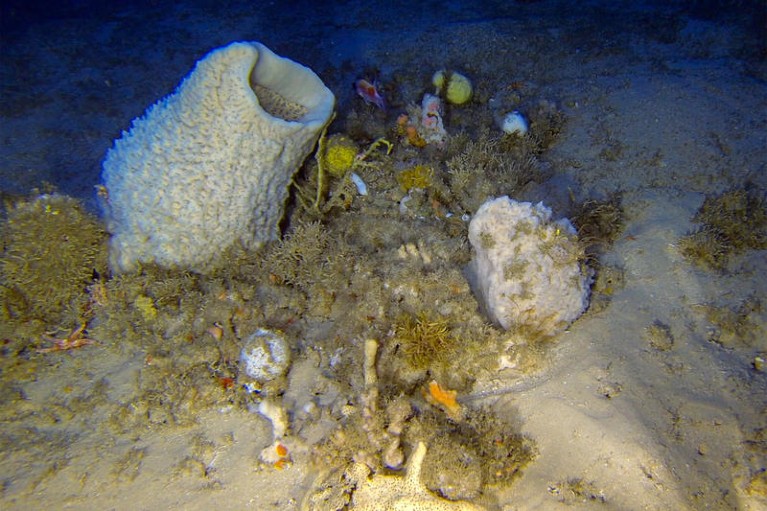
The Great Amazon Reef System is home to sea sponges and other organisms.Credit: Greenpeace
Offshore drilling has been beneficial to Brazil in the past: in particular, drilling off the southeast coast in basins near São Paulo and Rio de Janeiro brought a windfall. In 2010, Petrobras raised more than US$25 billion for exploratory drilling in the region. Aloizio Mercadante, president of the Brazilian Development Bank in Rio de Janeiro, has estimated that the Equatorial Margin — a region that stretches over 2,200 kilometres along Brazil’s north coast and includes FZA-M-59 — could yield between 10 billion and 30 billion barrels of oil.
But researchers think it’s premature to make such estimates when oil hasn’t been found yet. And they aren’t convinced that Petrobras has properly assessed the impact of the drilling. The company says its oil-spill modelling fulfils Ibama’s requisites. “The results indicate that there is no likelihood of [oil] touching the Brazilian coast” in the event of a leak, Petrobras says.
But the modelling did show that oil could reach French Guiana, Guyana, Suriname and the Caribbean, Rezende points out. He also says that the models used by Petrobras “do not consider wind-generated waves, which are quite intense in the region and would certainly pull oil to the coast”. Petrobras stands by its modelling, saying that it used the “most modern techniques and systems”.
Researchers worry that if oil were to reach the coast, it could damage mangroves at the mouth of the Amazon. “The region houses the second-largest continuous mangrove area in the world,” Francini-Filho says. “As it is highly sensitive, oil contamination would be catastrophic.”
A greener future?
Petrobras tells Nature it has drilled almost 3,000 wells at deep-sea sites without any complications, and that these, “added to the technical expertise and experience accumulated over 70 years, allow the company to open new frontiers with total security towards the Equatorial Margin’s environmental sensitivity”.
But even if the drilling can be done safely, researchers still question the idea of tapping into new oil reserves — which would create carbon emissions — while the world is battling climate change. Brazilian President Luiz Inácio Lula da Silva campaigned as an environmental crusader who would protect the country’s biodiversity and health. Allowing drilling in FZA-M-59 could cast doubt on his sincerity.
“Is this what we want as a country?” asks Araújo. If approved, the project wouldn’t begin producing oil until 2030. “How much will a barrel be worth by then, when nations are supposed to be converting to renewable energy?” she asks. “We should be thinking of a development plan for the twenty-first century.”
Ibama says it is analysing Petrobras’s latest request, but has set no date for a decision.
doi: https://doi.org/10.1038/d41586-023-02187-3


Comments
Post a Comment