Climate Change(El Niño and La Niña). Rings of fire: centuries of tree growth show wildfires increasing in Vietnam
Climate Changes. Rings of fire : centuries of tree growth show wildfires increasing in Vietnam
The data suggest human activities are more to blame for the increase than climate change. (Nature NEWS 19 July 2023)
 |
| Increasing human presence in and around Bidoup Nui Ba National Park has resulted in more frequent wildfires.Credit: Evgeniya Pavlova/Getty |
The first centuries-long analysis of wildfires in southeast Asia has been compiled using tree rings from a region in central Vietnam. There has been a drastic increase in the frequency of wildfires in the area over the past 100 years, but climate change is not the primary culprit. Instead, humans lighting fires for agriculture are behind the rising number of forest burns, according to the study1 published in Geophysical Research Letters.
“Fire has a big impact on the forest structure,” says Thiet Nguyen, a forest ecologist and PhD student at the University of Melbourne in Australia. “There’s a very high level of biodiversity in that forest.”
Many people think of tropical Vietnam as lush with jungle, but in the central highlands, misty montane forests are home to around 100,000 hectares of conifers mixed with broadleaf trees. Whereas tropical trees don’t tend to put on annual growth rings because they grow consistently year-round, the conifers have annual cycles of growth. Nguyen and his colleagues took cross-sections from recently fallen trees of two species, Pinus kesiya and Keteleeria evelyniana, at 12 locations in Bidoup Nui Ba National Park and counted the tree rings back over almost 400 years.
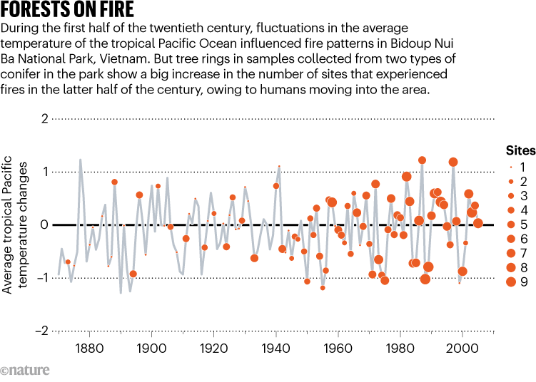
When trees are exposed to non-lethal fires, their bark chars, leaving behind a burn scar in the tree rings. The team dated the earliest definite fire scar to 1772. Between then and 1905, only 17% of years contained clear fire scars, although Nguyen admits that the farther the researchers went back in time, the smaller was the available number of samples, reducing their confidence in the findings. After 1905, they had good, clear tree rings to work with. From then until 1963, 71% of years showed scars from fires; however, the fires often affected only a small number of sites. But from 1964 to the present day, fire has occurred almost every year, often affecting a larger number of sites.
‘A big problem’
Until the advent of this study, “we had no idea how the fire regime has been changed”, says Nguyen. “If the fires are increasing rapidly, that can reduce biodiversity and forest density,” he adds. “It’s a big problem.”
Using statistical analysis, the authors looked for relationships between fires, climate and the human population. They discovered that historically, fire patterns were associated with climate; data from Pacific sea surface temperatures (see ‘Forests on fire’) showed that weather patterns such as El Niño and La Niña, which determine dry or wet years, could have influenced how much combustible plant material was available and how dry and flammable it was, for example.
But after 1963, according to population estimates for the nearby city, Da Lat, an increasing number of people came to live in the area. Humans use fire to clear land for agriculture, Nguyen says, and fire probably spreads to the national park — established in 2004 — from nearby areas. People also start fires in the park. From 1964, the authors found that the signal from humans overwhelmed climate as the driving force behind the fires.

Source: doi: https://doi.org/10.1038/d41586-023-02235-y
The fires’ increasing frequency, coupled with heightened fire conditions brought on by climate change, will be a problem in the future, says Brendan Buckley, a dendrochronologist at Columbia University in New York, who was a master’s programme adviser to Nguyen but was not involved in this study. “There might very well be some burning that gets out of control in these areas that are protected rainforest.”
Understanding historical and modern fire occurrence is crucial because it gives researchers a baseline to work from, helping forest managers to prepare for climate change, Buckley says. Although fire can be beneficial to a coniferous forest, the rainforest is a totally different ecosystem and can be destroyed by fire, he says.
Nguyen says that the species used in this study are common across other parts of southeast Asia, such as Thailand and the Philippines, meaning that the same technique could be used to explore fire history and climate change in other countries.
“If we had this kind of study in other countries in southeast Asia, a big historical fire reconstruction for the region, that would be cool.”
doi: https://doi.org/10.1038/d41586-023-02235-y


Comments
Post a Comment