Unraveling the environmental impact of North Sea shipwrecks

Unraveling the environmental impact of North Sea shipwrecks


 The haunting presence of shipwrecks such as the John Mahn in the North Sea offers glimpses into our history. These maritime time capsules, while fostering vibrant ecosystems, raise concerns about pollution and leakage. However, thanks to the groundbreaking North Sea Wrecks project, the hidden dangers and self-cleaning properties of these enigmatic relics are being uncovered. Are we truly facing a toxic war legacy, or are our worries unfounded? Testerep, a magazine of the Flanders Marine Institute (VLIZ), embarked on an investigative journey to shed light on this.

There are approximately 290 shipwrecks in the Belgian part of the North Sea alone, and more than 1,000 in the entire North Sea. These wrecks, remnants of the world wars, have long been a mystery in terms of their environmental impact and potential for toxic substance release. However, the North Sea Wrecks project aimed to change that, and researchers examined the ammunition load and release of toxic substances from a few selected wrecks in the North Sea. Testerep magazine sought answers concerning the presence of a toxic war legacy.

Oil leakage and war ammunition

One such wreck is the John Mahn, which sank during World War II off the Belgian coast, leaving 27 crew members missing. The wreck, along with numerous others, remains a silent witness to the wars, intriguing researchers and historians alike.

Shipwrecks in the sea can create biodiversity hotspots, attracting various marine life and organisms. However, the exact locations and conditions of these wrecks, along with their negative environmental impact, remain largely unknown. Oil pollution is one well-studied issue, with examples such as the USS Arizona, sunk during World War II, still leaking oil after 82 years. Moreover, wrecks may contain liquid fuel, coal, chemicals or dangerous cargo. The presence of war ammunition is also a concern, as its condition, quantity and potential leakage remain uncertain.

The North Sea Wrecks project, initiated in 2018, united nine partners across several North Sea countries. They aimed to develop an instrument to estimate the potential environmental impact of wrecks before commencing sea-related activities. The project focused on 15 case studies from over 1,000 known shipwrecks in the region.

Self-cleaning properties

Through water and sediment sampling, as well as the use of mussels and fish as bioindicators, researchers discovered that two thirds of the studied wrecks still contained ammunition, resulting in the leakage of toxic substances such as TNT. However, the measured concentrations were well below harmful levels for humans and animals, and the wrecks exhibited self-cleaning properties through bacterial communities.

In response to the environmental risks posed by leaking ammunition, the follow-up project REMARCO (Remediation, Management, Monitoring and Cooperation addressing North Sea UXO) has been approved. VLIZ and the Royal Belgian Institute of Natural Sciences (RBINS – OD Nature) will collaborate to develop better detection techniques for ammunition leaks and explore strategies to combat pollution caused by war wrecks.
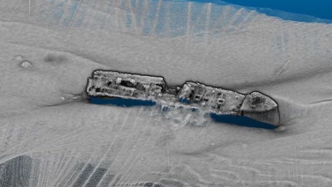
The wreck of the John Mahn is situated at a depth of 35 metres on the floor of the North Sea off the coast of Belgium, depicted here in a sonar image. (Image courtesy: Flanders Marine Institute – VLIZ)


https://www.hydro-international.com/content/news/unraveling-the-environmental-impact-of-north-sea-shipwrecks?utm_source=newsletter&utm_medium=email&utm_campaign=Newsletter+%7C+Hydro+%7C+20+June+2023+&sid=183140

Comments

Popular posts from this blog

Von Kármán vortex cloud swirls from Jeju Island of Republic of Korea (South Korea)

    This Copernicus Sentinel-3 image acquired on 19 April 2021 shows several vortical cloud patterns swirling downwind south of the Spanish Canary Islands, off the coast of northwestern Africa.   These beautiful spiral clouds, known as Von Kármán vortices, form when atmospheric circulation is disturbed by the presence of mountainous obstacles. The peculiar spiral clouds which can be seen in this image were formed as the wind airflow was deflected by the relief of the Canary Islands. These Von Kármán vortices can be seen extending 400 km southwest due to the strong trade winds that were blowing at the time the image was acquired.   The study of atmospheric phenomena is fundamental to the understanding the fluid dynamics that underly numerous scenarios of our daily lives, from aircraft take-offs to the change in weather conditions. Open data supplied by the Copernicus Sentinel-3 mission are crucial in the advancement of scientific knowledge on cloud dynamic...

Major Storm Hits Northern California: Flash Flooding and Rockslides Threaten Region

  Major Storm Hits Northern California: Flash Flooding and Rockslides Threaten Region   SANTA ROSA, Calif. (AP) — A powerful storm swept through Northern California on Wednesday night, bringing heavy rain and snow, and posing significant threats of flash flooding and rockslides.   Key Details - Rainfall: Up to 16 inches (41 cm) of rain forecasted in Northern California and southwestern Oregon through Friday. - Snowfall: Over a foot of snow already dumped in the Cascades, with more expected in the northern Sierra Nevada. - Wind: Wind gusts could reach up to 75 mph (121 kph) in mountain areas. - Power Outages: Nearly 376,000 reports in Washington state due to strong winds and rain. - Casualties: Two fatalities in Washington state due to falling trees.   CNN news Impact on Northern California - Santa Rosa: Experienced about 5 inches (13 cm) of rain within 24 hours. - Road Closures: Southbound Interstate 5 closed for 11 miles (18 km) due to extreme weather co...

Climate change is changing hurricanes. How?

Climate change is changing hurricanes. How?  #EarthScience #NASA #Hurricanes #ClimateChange  Image Descriptions 1: An image of Hurricane Idalia from space taken by an astronaut aboard the ISS is positioned in the bottom half of the image. White text reads “Climate change is affecting Hurricanes.” with “hurricanes” in blue lettering on a black background at the top.  2: An image divided into four panels by blue lines. The left most panel runs top to bottom showing a piece of the image from the previous slide while the other three panels divide the right side of the image. The top is white text on a black background and reads “How do hurricanes form?”. The middle shows an image of an eye of a hurricane from space. The bottom panel reads “4 main ingredients:” in blue text and lists “Warm ocean waters near the surface, High humidity in the air, Favorable winds, and A pre-existing disturbance (like a cluster of thunderstorms”  3: An image with white text on a black backgr...