Machine learning comes to the fore at EGU conference
Machine learning comes to the fore at EGU conference

Machine learning was a prominent theme to which ECMWF scientists contributed at the European Geosciences Union (EGU) General Assembly 2023, while other issues related to weather forecasting across different timescales were represented, too.
The General Assembly in Vienna, Austria, brings together geoscientists covering all disciplines of Earth, planetary, and space sciences.
About 25 of the Centre’s scientists participated in the event from 23 to 28 April. They also helped to prepare it, for example by supporting Early Career Scientists.
Machine learning
Several scientists took their expertise and current research in machine learning to the conference.
“We’re seeing an increase in the complexity of machine learning models demonstrated, and there was a wide range of applications,” says ECMWF scientist Mat Chantry.
Mat Chantry opened the machine learning session on the first day with a well-attended presentation.
His talk was about training on data generated from an existing parametrized physical process in ECMWF’s Integrated Forecasting system (IFS).
Slide from Mat Chantry’s presentation on ‘Emulating radiative transfer in a numerical weather prediction model’.
Mariana Clare gave a talk on extracting reliable and trustworthy probabilistic information from deterministic forecast runs. Her talk was related to the EU’s Destination Earth initiative, where she is exploring “the use of probabilistic machine learning as the high resolutions considered by the project mean that a full 50-member ensemble global forecast may be difficult to run computationally”.
Mariana Clare’s talk was on ‘Combining Bayesian Neural Networks with explainable AI techniques for trustworthy probabilistic post-processing’.
Michel Wortmann says there were “a lot of machine learning/artificial intelligence contributions” in the Hydrological Sciences section of the conference. “In particular, hybrid and explainable AI approaches are popular,” he says.
Other contributions
Gianpaolo Balsamo gave an overview of recent progress and the outlook for ECMWF’s IFS on behalf of Director-General Florence Rabier.
He noted in particular the creation of higher-resolution ensemble forecasts, from a horizontal resolution of 18 km down to 9 km, to be implemented this summer.
The upgrade to an ensemble resolution of 9 km will be implemented in ECMWF’s next model upgrade to IFS Cycle 48r1.
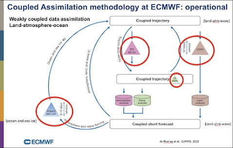
Patricia de Rosnay had prepared a presentation on how different parts of the Earth system are combined at ECMWF to establish the initial conditions of weather forecasts through data assimilation. Her talk was given by Éric de Boisséson.
Slide from Patricia de Rosnay’s presentation on ‘Coupled data assimilation for numerical weather prediction at ECMWF’.
Éric also presented a poster on preparations for ECMWF’s new ocean and sea-ice reanalysis system (ORAS6/Ocean6). “There was a lot of interest from viewers in the role of ORAS6/Ocean6 in the context of ECMWF’s Earth system approach, its place within coupled data assimilation for numerical weather prediction and reanalysis, and its link with the upcoming ERA6 reanalysis.”
Michael Mayer gave a presentation on difficulties of hindcasts from ECMWF's seasonal forecasting system SEAS5 in representing trends in tropical sea-surface temperatures since 1993.
“There was a second talk in this session that pointed out similar deficiencies in other seasonal forecasting systems,” Michael observes. “The two talks sparked quite some discussion during the session and afterwards, which to me signified that people acknowledge the importance of this aspect for operational prediction of the El Niño–Southern Oscillation (ENSO).”
Michael Mayer presented differences between seasonal forecasts of La Niña-related cool sea-surface temperatures for different start dates 1998–2000 and 2020–2022.
Michel Wortmann gave a presentation in a Hydrological Sciences session on ‘A global 30 m bifurcating river network’. This new Global River Topology (GRIT) is the first to also describe the diverging flow of rivers in deltas, canals and braided rivers, using high-resolution, recent Earth observation data.
“This new dataset attracted plenty of interest in the session and will make large-scale flood simulations more locally relevant,” he says.
ECMWF scientists were also involved in preparing for the EGU General Assembly. For example, as the Hydrological Sciences (HS) division Early Career Scientist representative, Florentine Weber was a key member of the organising team.
Florentine Weber participated in the conference virtually as a co-convener of a packed Early Career Scientists’ meeting. (Credit: Elena Cristiano)
The HS division is the largest of the EGU’s 22 scientific divisions, with about 15% of all abstracts for this year’s event and 2,467 presentations across 96 sessions.
A complete list of contributions by ECMWF scientists, including presentations on numerical weather prediction and EU-funded Destination Earth and Copernicus activities, is available on our website.


Comments
Post a Comment