Posts

Showing posts from January, 2024

Changes in the Atlantic Meridional Overturning Circulation (AMOC) and its transport of heat can affect climate and weather patterns, regional sea levels, and ecosystems

Changes in the Atlantic Meridional Overturning Circulation (AMOC) and its transport of heat can affect climate and weather patterns, regional sea levels, and ecosystems! A new study led by Ivenis Pita, a @miamirosenstiel PhD student working at #AOML/ @cimas_rosenstiel, is the first to estimate the AMOC and heat transport at 22.5°S in the South Atlantic.  This study presents a new mapping method based on sustained ocean observations: a high-density expendable bathythermograph (XBT) transect to resolve the strong currents in the western boundary; low density Argo profiling floats across the basin; and satellite sea level data to determine the mapping parameters and errors associated with these estimates. This observing system was named AXMOC (for Argo-XBT-MOC). To learn more, click the link in bio! Photo 1 📸: In situ measurements used in the study. The locations of the Argo and XBT profiles are represented by blue and red dots, respectively. The reference transect at 22....
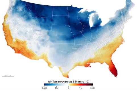
Much of the U.S. has been experiencing dangerously cold temperatures and winter weather.

A large mass of Arctic air that moved south from Canada brought cold, wintry weather in mid-January 2024 that extended from the Pacific Northwest all the way to the East Coast. The cold reached as far south as Texas and Louisiana. NASA’s Aqua satellite captured this view of snow and clouds over the Great Lakes on Jan. 16, 2024. The map shows near-surface air temperatures at 7 a.m. EST on Jan. 15 from NASA’s Goddard Earth Observing System Model (GEOS), which uses data from NASA satellites and other sources.  Another surge of frigid Arctic air is forecast to spread over the eastern half of the country on January 19 and 20, though it won’t be as extreme according to weather reports. But wait… wasn’t 2023 the hottest year on record? If Earth is experiencing a long-term warming trend, why do these cold events occur?  That’s a matter of weather versus climate. Weather typically refers to short-lived, while climate refers to longer-term averages and usually ov...

NOAA’s GOES West satellite captured this stunning visible imagery of von Kármán vortices

On Jan. 17, 2024, NOAA’s GOES West satellite captured this stunning visible imagery of leaf-shaped actinoform clouds forming next to swirling von Kármán vortices near Guadalupe Island. https://www.instagram.com/reel/C2SzvhfxWuB/?igsh=NTc4MTIwNjQ2YQ== Von Kármán vortices are beautiful swirling cloud formations that typically occur when the prevailing wind is diverted by elevated land features such as islands, mountaintops, or volcanoes. These geological features can disrupt the flow of wind, causing the air, and its subsequent clouds, to rotate into a spiral shape. This is similar to the way large boulders create downstream eddies in rivers. The pattern of the cloud swirls depends on the wind intensity. The vortices are driven by the prevailing winds, which can change seasonally and cause differences in the direction and structure of the vortices. Actinoform clouds are organized in a distinctive radial pattern, often appearing as leaf-like or reminiscent of wagon wheel spoke...